EXPLORE THE DIVERSE AND BREATH TAKING TOURISTS SITES ACROSS SOUTH AFRICA
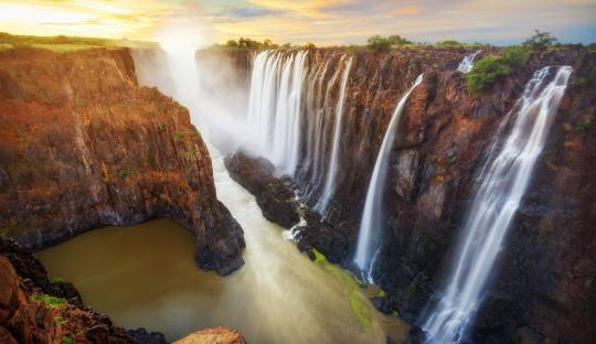
VICTORIA FALLS:
Falls, located on the Zambezi River at the border between Zambia and Zimbabwe, is one of the world's most spectacular natural wonders. Its history spans geological formations, indigenous cultures, European exploration, and modern tourism.
Geological Formation
The basalt plateau over which the Zambezi River flows was formed during the Jurassic period, around 200 million years ago.
Indigenous Knowledge
Long before European explorers arrived, local communities were well aware of the falls. The southern Tonga people, known as the Batoka or Tokalea, referred to it as "Shungu na mutitima," meaning "Boiling Water." The Matabele called it "aManz' aThunqayo," and the Batswana and Makololo (whose language is used by the Lozi people) called it "Mosi-oa-Tunya," both translating to "The Smoke That Thunders."
European Exploration
In November 1855, Scottish missionary and explorer David Livingstone became the first European to view the falls. He named them "Victoria Falls" in honor of Queen Victoria. Prior to Livingstone's visit, the falls were known to local tribes, and some European explorers may have been aware of them.
Colonial Era and Tourism Development
European settlement in the Victoria Falls area began around 1900, driven by the British South Africa Company's interests in mineral rights and imperial expansion. The construction of the Victoria Falls Bridge in 1905 facilitated access to the region, leading to the establishment of the Victoria Falls Hotel to accommodate visitors. The area became a popular tourist destination during British colonial rule of Northern Rhodesia (now Zambia) and Southern Rhodesia (now Zimbabwe).
Post-Independence Period
In 1964, Northern Rhodesia gained independence as Zambia, followed by the unilateral declaration of independence by Rhodesia in 1965. The region experienced political and economic challenges, including the Rhodesian Bush War from 1972 to 1980. Despite these challenges, the 1980s saw a resurgence in tourism and the development of adventure sports such as whitewater rafting and bungee jumping.
Recent Developments
By the late 1990s, nearly 400,000 people were visiting the falls annually, with expectations of over a million visitors in the following decade. However, political tensions in Zimbabwe in the early 2000s led to a decline in tourism on the Zimbabwean side, while the Zambian side saw increased visitor numbers. The United Nations has expressed concerns about the environmental impact of tourism and the need for effective management to preserve the falls' status as a World Heritage Site.
Today, Victoria Falls remains a major tourist attraction, drawing visitors worldwide to witness its breathtaking beauty and engage in various adventure activities.
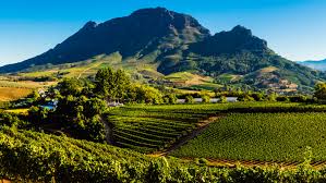
CAPE WINELAND:
The Cape Winelands, situated in South Africa's Western Cape province, boast a rich history intertwined with the development of viticulture in the region.
Early Beginnings
In 1659, Jan van Riebeeck, the founder of Cape Town, produced the first recorded South African wine. This initiative was part of the Dutch East India Company's strategy to establish a refreshment station for ships traveling between Europe and Asia.
French Influence
In 1688, French Huguenot refugees settled in the Franschhoek Valley, bringing with them advanced winemaking techniques and grape varieties. This migration significantly enhanced the quality and diversity of wines produced in the region.
Expansion and Recognition
Throughout the 18th and 19th centuries, the Cape Winelands expanded, with estates like Constantia gaining international acclaim. The Constantia estate, established in 1685, became renowned for its 'Vin de Constance,' a sweet wine favored by European royalty.
Modern Developments
In 1971, the first official wine route was established in Stellenbosch, marking a significant step in promoting the region's wines.
Today, the Cape Winelands are celebrated for their diverse wine offerings and rich history, attracting wine enthusiasts from around the world.
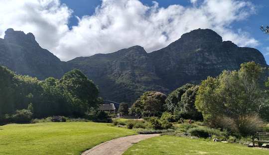
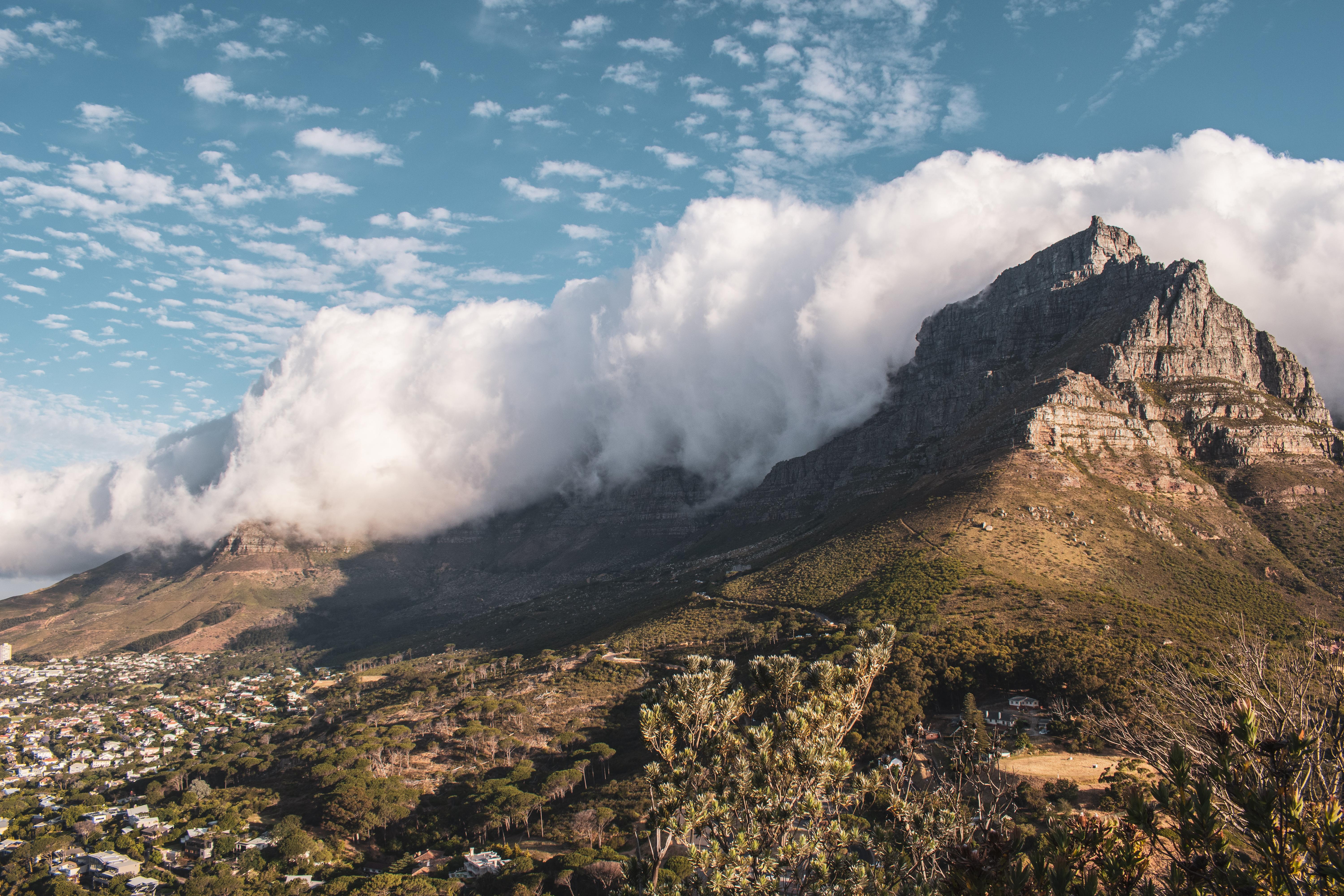
TABLE MOUNTAIN:
The Table Mountain is an iconic landmark overlooking Cape Town, South Africa, boasts a rich history that spans geological formations, indigenous cultures, European exploration, and modern conservation efforts.
Geological Formation
Approximately 300 million years ago, during the Carboniferous period, Table Mountain began forming as layers of sandstone were deposited. Over time, these layers were uplifted and shaped by erosion, resulting in the mountain's distinctive flat-topped appearance.
Indigenous Significance
The Khoi and San peoples, the original inhabitants of the Cape region, referred to Table Mountain as "Hoerikwaggo," meaning "Mountain in the Sea." They considered it a sacred site, believing their god resided there.
European Exploration
In 1503, Portuguese admiral António de Saldanha became the first European to ascend Table Mountain, naming it "Taboa do Cabo" (Table of the Cape). This marked the beginning of European interest in the region.
Colonial Era
In 1652, Jan van Riebeeck established a Dutch settlement at the Cape, leading to the displacement of indigenous communities and the introduction of European agricultural practices. During the British occupation in 1796, Major-General Sir James Craig ordered the construction of blockhouses on Table Mountain to defend against potential attacks.
Conservation and Recognition
In 1998, the Table Mountain National Park was established, encompassing the mountain and surrounding areas to protect its unique biodiversity. In 2011, Table Mountain was named one of the New7Wonders of Nature, highlighting its global significance.
Today, Table Mountain stands as a symbol of Cape Town's natural beauty and cultural heritage, attracting millions of visitors annually.
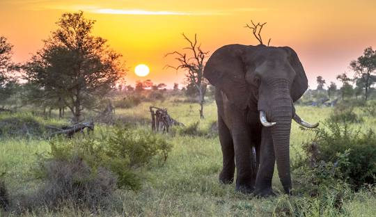
KRUGER NATIONAL PACK:
Kruger National Park, one of South Africa's premier wildlife reserves, boasts a rich history that intertwines indigenous cultures, colonial exploration, and conservation efforts.
Indigenous Inhabitants
Long before European explorers arrived, the region was inhabited by the San people, who left behind rock art and artifacts, reflecting their deep connection to the land.
European Exploration and Early Conservation
In the late 19th century, European settlers began exploring the area. Recognizing the region's ecological significance, the South African Republic established the Sabi Game Reserve in 1898, covering approximately 10,364 km². This initiative marked the beginning of formal conservation efforts in the area.
Expansion and Formalization
In 1926, the reserve was renamed Kruger National Park in honor of President Paul Kruger. The park's boundaries expanded, and infrastructure improved, including the construction of roads and rest camps, making it more accessible to visitors.
Modern Developments
Today, Kruger National Park spans nearly 20,000 km² and is renowned for its biodiversity, including the "Big Five"—lion, leopard, rhinoceros, elephant, and Cape buffalo. It stands as a testament to successful conservation and a vital component of South Africa's natural heritage.